Technical expertise in hard skills, such as data analysis, design software skill, and prototyping techniques, is essential for R&D engineers to innovate effectively.
R&D Engineer Resume Examples & Templates
Looking to make your mark as an R&D engineer? Our R&D engineer resume examples help you showcase your analytical skills and technical expertise, catching the eye of potential employers.

by Gabriela Hernandez, Last Updated: January 23, 2026
Hired By:*

Popular R&D Engineer Resume Examples
Discover our top r and d engineer resume examples that emphasize critical skills like innovation, project management, and technical expertise. These examples will help you showcase your accomplishments effectively to potential employers.
Looking to build your own impressive resume? Our Resume Builder offers user-friendly templates specifically designed for engineering professionals, making your application process seamless.
Recommended
 Customize This Resume
Entry-level R&D engineer resume
What this resume does well:
This entry-level resume effectively highlights the applicant's strong background in product design and project management, showcasing significant achievements such as leading teams and improving efficiency. New professionals in the R&D engineering field must demonstrate their technical skills, innovative thinking, and ability to collaborate across teams to attract potential employers despite limited work experience.
Mid-career R&D engineer resume
What this resume does well:
This resume effectively showcases a strong foundation in engineering and a history of strong contributions, indicating readiness for leadership roles. The job seeker's progression from innovation specialist to R and D engineer highlights their capability to manage complex projects and drive technological advancements.
Experienced R&D engineer resume
What this resume does well:
The work history highlights the applicant's ability to drive innovation and efficiency. Achievements include increasing product design efficiency by 40% and generating $500K annual market growth, with clear formatting improving readability for potential employers.
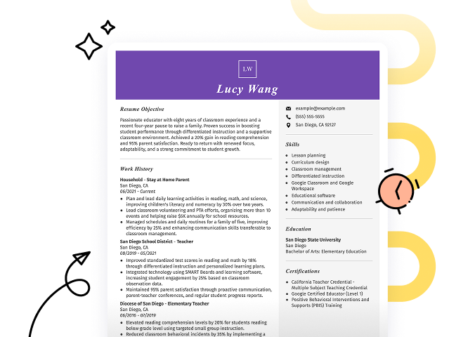
Resume Template—Easy to Copy & Paste
Example
Suki Chen
Jersey City, NJ 07311
(555)555-5555
Suki.Chen@example.com
Skills
- AI Model Development
- Cross-Department Collaboration
- Sensor Design Optimization
- Project Management
- Process Improvement
- Material Science
- Research Publication
- Cost Reduction Strategies
Languages
- Spanish - Beginner (A1)
- Chinese - Intermediate (B1)
- French - Beginner (A1)
Professional Summary
Dynamic R&D Engineer with expertise in AI model development, process improvement, and cross-department collaboration. Proven ability to enhance accuracy by 25% and lead projects with multi-million dollar budgets. Passionate about driving innovation and sustainability in engineering solutions.
Work History
R and D Engineer
FutureTech Innovations - Jersey City, NJ
March 2022 - January 2026
- Developed a new AI model with 25% accuracy improvement
- Led a team to reduce product defect rate by 30%
- Initiated cross-departmental collaboration projects
Product Development Specialist
Precision Dynamics - Maplewood, NJ
January 2018 - February 2022
- Enhanced sensor design resulting in 15% cost reduction
- Implemented process improvements increasing efficiency by 18%
- Coordinated international project with a 2M budget
Research Scientist
Innovatech Labs - Maplewood, NJ
January 2017 - December 2017
- Published 12 research articles in leading journals
- Conducted experiments improving yield by 12%
- Designed a novel material with 40% increased durability
Certifications
- Certified Robotics Engineer - Robotics Institute of America
- Advanced Data Analysis Certificate - Data Science Institute
- Machine Learning Specialist - The Tech Academy
Education
Master of Science Mechanical Engineering
Stanford University Stanford, CA
June 2016
Bachelor of Science Electrical Engineering
University of California, Berkeley Berkeley, CA
June 2014
Build Your Resume in Minutes
Creating a custom resume is easier than ever with our Resume Builder!
How to Write a R&D Engineer Resume Summary
Your resume summary is the first impression you make on hiring managers, making it important to clearly convey your qualifications and experiences. As an R&D engineer, it's essential to highlight your technical skills, problem-solving abilities, and innovative mindset that drive successful product development. To guide you in crafting an effective summary, we'll present examples that illustrate what resonates well with employers and what might fall short:
Weak Example
I am a skilled R&D engineer with many years of experience in various projects. I hope to find a position that allows me to use my expertise and contribute positively to a company. A supportive work environment with chances for career advancement is what I am looking for. I believe I can be an asset if given the chance.
Why this summary misses the mark:
- Lacks specific details about the job seeker’s technical skills or achievements, making it vague
- Overuses personal pronouns and focuses on personal desires rather than what value they bring to potential employers
- Fails to highlight relevant accomplishments or unique contributions that set the job seeker apart from others
Strong Example
Innovative R&D Engineer with over 7 years of experience in developing cutting-edge technologies for consumer electronics. Spearheaded a project that resulted in a 30% increase in product efficiency, leading to a $1M cost savings annually. Proficient in CAD software, prototyping techniques, and cross-functional team collaboration to drive product development from concept to launch.
Why this summary works:
- Begins with clear experience level and industry focus
- Highlights quantifiable achievements that indicate significant contributions and financial impact
- Showcases relevant technical skills essential for the R&D engineering position
Pro Tip
If you're just starting out and don't have much formal experience, consider using a career objective on your resume. This approach helps highlight your ambitions and skills. Check out various resume objective examples tailored for R&D engineering to get inspired.
Showcasing Your Work Experience
The work experience section is the cornerstone of your resume as an r and d engineer. This is where you'll provide the bulk of your content, and effective resume templates always prioritize this important section.
Organize this part chronologically, starting with your most recent positions. Use bullet points to highlight key achievements and contributions in each role, making it easy for hiring managers to see your impact at a glance.
To illustrate what makes an effective work history entry for r and d engineers, we'll present a couple of examples that showcase best practices and common pitfalls:
Weak Example
R and D Engineer
Tech Innovations Inc. – San Francisco, CA
- Conducted experiments.
- Made reports and presentations.
- Collaborated with team members.
- Used advanced tools for testing.
Why this work experience section misses the mark:
- No employment dates provided
- Lacks detail on specific skills or technologies used by the applicant
- Focuses solely on routine tasks rather than accomplishments or innovations made
Strong Example
R&D Engineer
Tech Innovations Inc. – San Francisco, CA
March 2020 - Present
- Develop and implement innovative product designs, leading to a 30% reduction in production costs.
- Conduct testing and analysis to improve product performance, achieving a 15% increase in efficiency metrics.
- Collaborate with cross-functional teams to streamline project timelines, resulting in on-time delivery for 95% of projects.
Why this work experience section works:
- Starts each bullet with compelling action verbs that clearly demonstrate the job seeker's contributions
- Incorporates quantifiable results and percentages that illustrate the tangible impact of the applicant's work
- Highlights relevant skills such as teamwork and innovation to show how they align with job expectations
While your resume summary and work experience are important components, remember that other sections also deserve your focus. Each part of your resume plays a role in showcasing your skills and qualifications. For more detailed insights, explore our comprehensive guide on how to write a resume.
Top Skills to Include on Your Resume
Including a skills section on your resume is important as it offers a quick snapshot of your qualifications to potential employers. This concise overview allows job seekers to highlight their strengths effectively, making it easier for hiring managers to identify suitable job seekers.
Add both hard and soft skills to create a well-rounded resume.
Soft skills are essential for R&D engineers because they foster teamwork, improve problem-solving abilities, and facilitate clear communication, all of which drive innovation and lead to successful project outcomes.
When selecting skills for your resume, it's essential to align with what employers expect from job seekers. Many organizations use automated screening systems that filter out applicants lacking key resume skills, so careful consideration is important.
To improve your chances of catching a recruiter's eye, examine job postings closely. They often highlight specific resume skills in demand, guiding you on which attributes to prioritize for both human reviewers and ATS algorithms.
Pro Tip
Use our ATS Resume Checker to ensure your resume stands out. This tool identifies over 30 common errors, increasing your chances of passing applicant tracking systems.
10 skills that appear on successful R&D engineer resumes
Improve your resume's appeal to recruiters by highlighting high-demand skills relevant to R&D engineer roles. These sought-after skills can be observed in various resume examples, providing you with a competitive edge in your job applications.
By the way, consider integrating these key abilities into your resume if they align with your experience and the job specifications:
Analytical thinking
Problem-solving
Project management
Technical skill
Creativity
Attention to detail
Collaboration
Data analysis
Software development
Research methodologies
Based on analysis of 5,000+ engineering professional resumes from 2023-2024
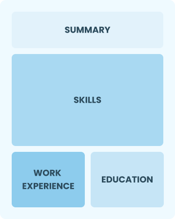
Resume Format Examples
Selecting the right resume format is important for R&D engineers, as it effectively showcases your technical skills, project experience, and career advancements in a clear and compelling way.
Entry-Level 0 - 2 years
Functional
Focuses on skills rather than previous jobs
Best for:
Recent graduates and career changers with up to two years of experience
Mid-Career 3 - 7 years
Combination
Balances skills and work history equally
Best for:
Mid-career professionals focused on demonstrating their skills and potential for growth
Experienced 8+ years
Chronological
Emphasizes work history in reverse order
Best for:
Seasoned engineers leading innovative research and development projects
Frequently Asked Questions
Should I include a cover letter with my R&D engineer resume?
Absolutely, including a cover letter is essential for making a strong impression on potential employers. It allows you to highlight your unique qualifications and demonstrate genuine interest in the position. If you need assistance crafting your cover letter, consider checking our comprehensive guide on how to write a cover letter or using our easy Cover Letter Generator for quick help.
Can I use a resume if I’m applying internationally, or do I need a CV?
When applying for jobs internationally, a CV is often required instead of a resume. A CV provides a comprehensive overview of your academic and professional history. For guidance on proper formatting and creation, explore our detailed resources on how to write a CV that can help you craft an effective document tailored to global expectations. Additionally, reviewing CV examples can provide inspiration and insight into creating your own standout CV.
What soft skills are important for R&D engineers?
Soft skills like problem-solving, collaboration, and adaptability are important for R&D engineers. These abilities, including interpersonal skills, foster teamwork and innovation. They enable engineers to effectively communicate ideas and tackle challenges together in their projects.
I’m transitioning from another field. How should I highlight my experience?
When applying for R&D engineer roles, highlight your transferable skills such as analytical thinking, project management, and teamwork. These abilities are valuable even if your experience in the engineering field is limited. Share specific examples from previous jobs to illustrate how your achievements relate to research and development tasks, showcasing your potential impact.
Should I use a cover letter template?
Certainly! Here's a revised version of the content with the required markdown link:
Yes, using a cover letter template tailored for an R&D engineer can improve your document's structure. This allows you to clearly present your technical skills, such as skill in CAD software and experience with project management, making it easier for hiring managers to recognize your qualifications.
How do I write a resume with no experience?
Creating a resume with no experience for R&D engineer positions is achievable by highlighting your academic projects, relevant coursework, internships, and technical skills. Emphasize your analytical thinking and problem-solving abilities. Employers value potential and eagerness to learn, so stay confident in your unique qualifications and ability to contribute.

Ready to land the job?
Join 28M+ others who've built a resume that works.